Powerful map visualisations and location-based analytics for both Qlik Sense and QlikView.
Qlik GeoAnalytics not only provides comprehensive mapping capabilities but also moves beyond visualisation with built-in spatial analysis support for a broad range of advanced geoanalytic use cases. This can help you reveal crucial geospatial information and expose hidden geographic relationships.
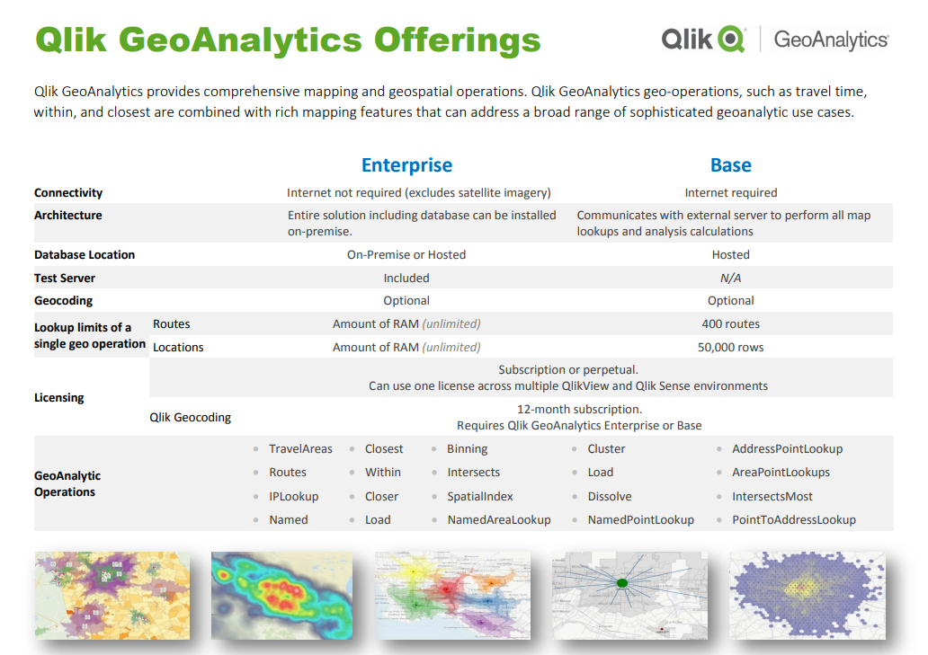
There are two GeoAnalytics offerings for Qlik Sense. GeoAnalytics Base and GeoAnalytics Enterprise. Your Qlik Sense comes bundled with GeoAnalytics Base.
In terms of mapping layers, the two offerings are identical – including bubble Layer, line Layer, area Layer, heatmap Layer and more.
In terms of geospatial operations, the two offerings are identical – including travel areas, routes, binning, closet points, clusters, with some limitations mentioned below.
Differences between GeoAnalytics Base and Enterprise
The main difference between the two is how geospatial data is fetched – Base communicates with an external server to perform map lookups and calculations. Enterprise allows you to host these on-premise (as well as communicate externally). That being said, Base requires an internet connection, while Enterprise does not.
Also, in Base the ‘maximum rows for Route Based operations’ is 400 rows, and Lookup Locations is limited to 50,000 rows, while Enterprise is unlimited for both. Route Based operations are Closest, Routes, and Travel Areas. The 400 row limit on Route Based operations would need to be considered for your intentions as mentioned below.
Here’s some more detail on the limits:
The 50,000 row Lookup Location limit is fairly straight forward. The 400 row limitation on Route Based operations is a little trickier.
For Travel Areas and Routes there is 1-1 relation. That is, 1 Route or Travel Area would leave you with 399 rows left. For Closest there are two datasets returned (for all X which is the closest Y). Neither of them can be larger than 400 rows. The limits are calculated at load time, so while 400 rows doesn’t sound much, you can split transactions to get around the limits (you can do this for both Travel Areas and Routes)
In fact, splitting is good practice even if there were no restrictions. This is explained further in this article.
There is also a separately licensed add-on called Qlik Geocoding – a service that adds address data lookup functionality to GeoAnalytics Base or Enterprise. Here you could provide the service with an address and it would return the location of that address on a map. The GeoAnalytics licence metrics are also useful, found here.

Great, How do I get started?
To get started with GeoAnalytics for Qlik Sense – simply install the Base that comes bundled with Qlik Sense, install the Qlik Sense extensions and start utilising Qlik GeoAnalytics.
Our team can help you through this process allowing you to start making the most of the functionality you already have!